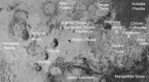

In the image above (North is up), you can see the general region of the
Viking 1 and Pathfinder landing sites, both in Chryse Planitia.
Some main features, like Amazonis Planitia, the Olympus Mons, Alba Patera,
Uranius Tholus, Ceraunius Tholus, Fesenkov, Tharsis Tholus, the 3 Tharsis
Montes, Valles Marineris, Tempe Terra, Sharonov, Chryse Planitia, Xanthe
Terra, Margaritifer Sinus, Acidalia Planitia, and Ares Vallis, have also
been marked.
The three Tharsis Montes are: North: Ascraeus Mons, Center: Pavonis Mons,
South: Arsia Mons
The image above is part of a map from the
Mars Atlas Web site.
Observatorio ARVAL marked the features on it.
For another good source of Mars' maps, link to the Planetary Data System's Mars Explorer.

A landing site has been chosen for the Mars Pathfinder at 19.5 N, 32.8 W,
in the Chryse Planitia, Ares Vallis area, NorthEast of Valles Marineris.
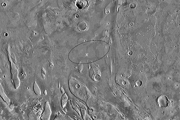
The site is shown above. The image shows the nominal landing area as an oval
superimposed on a Viking Orbiter image. The target landing point is at the
center of the 200 km by 70 km oval.
This image's resolution is approximately 32 pixels per degree =
1.8 kilometers per pixel = 1 nautical mile per pixel.
The top edge of this image is approximately at 23 degrees North.
The bottom edge of the image is approximately at 15 degrees North.
The image size is some 460 km (255 nm) North edge to South edge.
The actual landing site was at 19.33 N, 33.55 W, it is marked by an X in the image above.
NASA has selected an ancient flood plain on Mars as the landing site for
the Mars Pathfinder mission. Eons ago, when water flowed on Mars, great
floods inundated the landing site, located on a rocky plain in an area
known today as Ares Vallis. The site is 850 kilometers (527 miles)
southeast of the location of Viking Lander 1, which in 1976 became the
first spacecraft to land on Mars. Pathfinder will be the first to land on
Mars since the twin Viking landers arrived almost 21 years ago. The
spacecraft, scheduled to arrive at Mars on July 4, 1997, will parachute
down to Ares Vallis at the mouth of an ancient outflow channel chosen for
the variety of rock and soil samples it may present.
Ares Vallis, which meets the engineering constraints, was chosen after a
workshop earlier this year that involved the invited participation of the
entire scientific community concerned with Mars. More than 60 scientists
from the United States and Europe attended.
The Ares Vallis site is also a "grab bag" location, according to Golombek,
set at the mouth of a large outflow channel in which a wide variety of
rocks are potentially within the reach of the rover. Even though the exact
origins of the samples would not be known, he said, the chance of sampling
a variety of rocks in a small area could reveal a lot about Mars. The rocks
would have been washed down from highlands at a time when floods moved over
the surface of Mars.
Several potential sites were listed where ancient flood channels emptied
into Chryse Planitia, having cut through crustal units and ridged plains
where the water would have picked up material and deposited it on the
plain. All of the sites were studied using Viking orbiter data.
Updated: July 9 '97
Best seen with MS Internet Explorer.
Back to the Mars Pathfinder Page
Messages: